North Georgia Weather Center
  • Severe Weather Central
  • Winter Weather Threats
  • Hurricane Center 2014
  • School Closings
  • Blog
  • What to Do in a Tornado?

NGWC to Improve Communications with Threat Index

1/30/2014

0 Comments

 
Picture
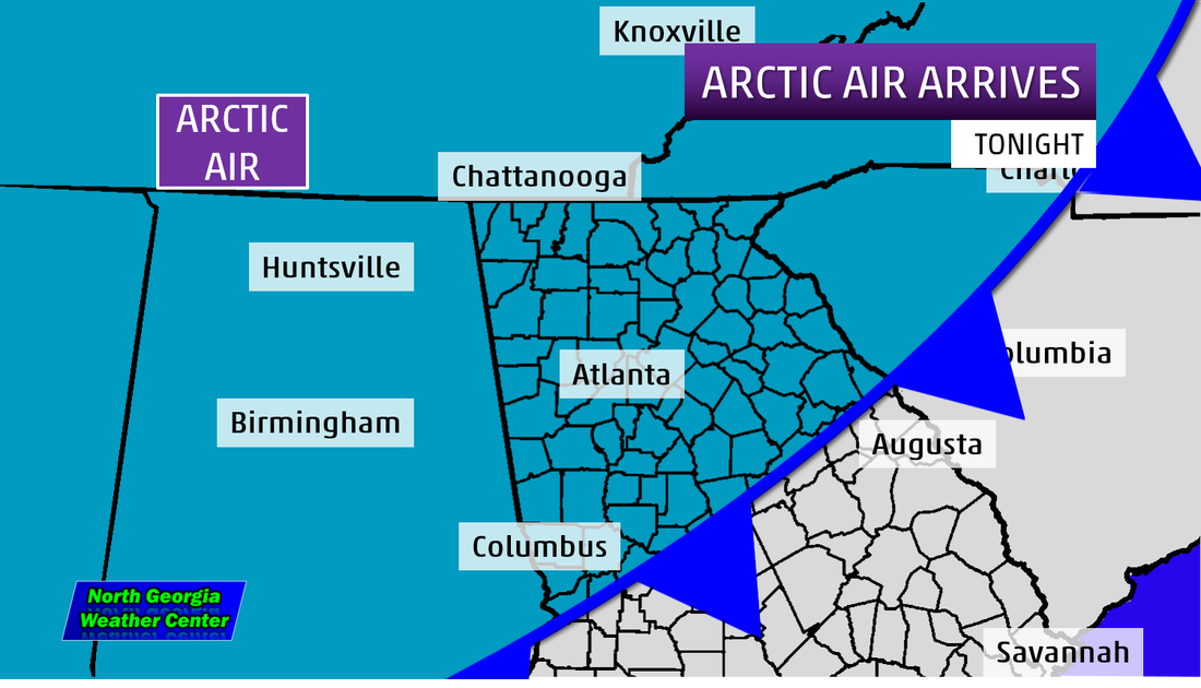
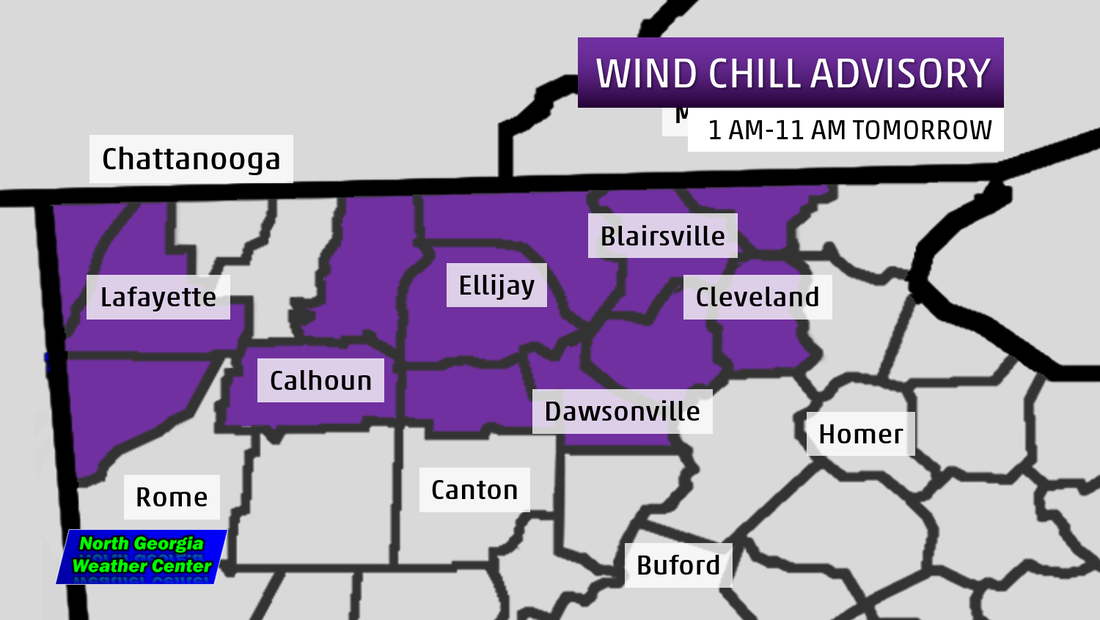
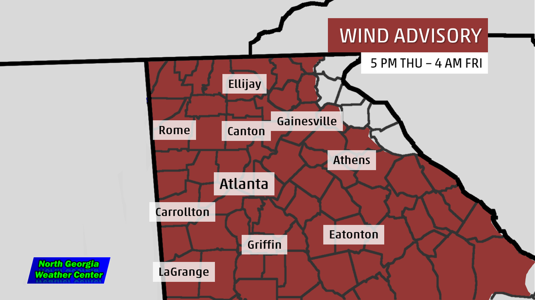
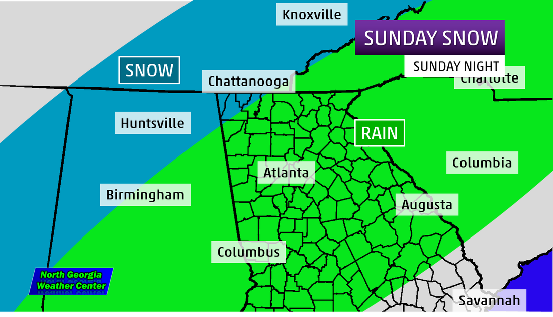
After the meltdown in Atlanta, and after a conference call we listened to last night, we are debuting a new graphic laying out the impacts likely to happen across Atlanta and across the mountains of North Georgia.

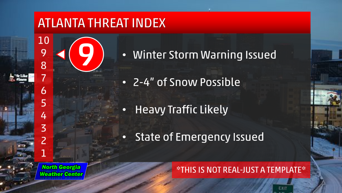
Because Atlanta officials dismissed the storm's impacts before it arrived, crippled the city. Because of that, we are announcing the Atlanta Threat Index. This is a scale on 1 to 10 that will layout the impacts and how it will effect you. Some factors that will be into place are...

  • timing of the day (overnight, middle of work day, weekend, ect.)
  • amount of snow or ice
  • length of time before a storm
  • type of product put out by NWS Atlanta (Winter Weather Advisory, Winter Storm Warning, ect.)
  • type of traffic expected

A sample of what the graphic will look like is above. The numbers will be on the left. The higher the number, the higher the impact. 


In the conference call we listened into last night, several on-camera meteorologist from around the country pointed out a big thing. People need to know not only the weather but also how the storm will impact them and their day. This will not be put out on a daily basis, only when a storm is threatening. We hope this will help people make their decisions on what to do in a incoming storm in North Georgia.
0 Comments

Coldest Air Since 1986 and Accumulating Snow This Week

1/3/2014

24 Comments

 
Picture
Picture
The COLDEST air since 1986 (yes, you read that right) is headed right here to North Georgia and it will be here in just a matter of days. But before we get that, we are talking more accumulating snow for the mountains and for the entire Metro Atlanta area. 

We will see rain move through Sunday night, but as the sun goes down, the temps will as well. When the temps fall, rain will transition to snow. Accumulations amounts stand as this. We could see trace to 1 in most spots but as we head into Gilmer, Fannin, Union, and Towns Counties we could see 2-3", the same in Dade and Walker. 
Picture
After the snow falls, we will see the temps will still TUMBLE. Start off in the Northwest Georgia Mountains we are looking at lows Tuesday morning as low as 2, only 2, two. The Northeast GA Mountains, the Tuesday morning low will be around zero. In metro Atlanta, we are talking lows near 9. Then, factor winds 23-30mph with 45 mph gusts. Its going to down right frigid. 


Of course, a lot of this will change as it approaches. We are confident on the cold air but the snow totals, they are just starters because they just came into range. We will have updates tomorrow! 
24 Comments

A HUGE Arctic Blast...Coldest Air in 3 years

1/2/2014

0 Comments

 
Picture
A Winter Weather Advisory is now in effect for parts of north Georgia through 7 AM tomorrow. Snow showers are likely with accumulations varying from a dusting to 1". Black ice is also a major concern as the wet roadways may freeze over to cause slippery conditions. If you have to go out tomorrow, wait until the sun comes up so you can somewhat see the ice.
Picture
Picture
Picture
Click on pictures for larger versions
Also tonight, lows will be well below average, in the 20s and teens. The wind will also be in full force in the mountains. That is prompting a rare WIND CHILL ADVISORY for Dade, Walker, Chattooga, Gordon, Murray, Fannin, Gilmer, Pickens, Dawson, Lumpkin, Union, Towns, and White Counties for wind chills between 10 and -5 degrees. In terms of wind, we will see sustained winds between 20-25 mph and wind gusts between 35-40 mph. Beware of falling trees and power lines as you could be without power for several hours an with temps in the teens and single digits, you don't want to be in that situation.
Picture
Per the National Weather Service in Peachtree City, a rain snow mix in LIKELY now in the north metro Atlanta area as we head into Sunday evening. It all starts out Sunday with a 70% Chance of Rain for the entire area but, as the sun goes down, the cold air returns. The rain will begin to transition to snow. It will turn to all snow in the mountains and we be ice in the north metro. It is still too early to pin point exact accumulation amounts if there is any as the ground is too warm at this point in time, but it may not be after these next few days. 
0 Comments

    Archives

    September 2014
    June 2014
    March 2014
    February 2014
    January 2014
    December 2013
    March 2013
    December 2012

    Categories

    All

    RSS Feed


Powered by Create your own unique website with customizable templates.